Cartography
After wallpapering my dorm room with old USGS quads, interning with both National Geographic and the National Park Service, I now make maps full time for Benchmark Maps and Raven Maps & Images. Here are some of my favorite projects, whether they came from work, freelance, or just mapping for fun.
I’m also played along with the #30DayMapChallenge on Twitter in 2023 and 2021.
Follow the links to see those galleries!
Great Smoky Mountains National Park
The Smokies are my home mountain range, the place that first got me excited about a life outdoors and where my love of cartography grew and developed through day hikes on my own and a lucky internship with the National Park Service. This map, built to be 8 feet wide and 4 feet tall, is my attempt to capture the grandeur of the landscape, the height and scale of these mountains, and the intricate network of 900+ miles of trails that wind through the park’s extensive backcountry. It’s the high country I’m most enamored with, so I gave extra attention to the shaded relief and hypsometric tinting, trying my best to illustrate just how tall these peaks are. Though they’re covered from head to toe in forest, the summits of the Smokies are not to be underestimated.


The High Sierra
Produced in a partnership between Natural Atlas and Muir Way, this map was a joy to work on. Highlighting some of the most spectacular landscapes I’ve experienced, it required a shaded relief treatment that would make the mountains pop alongside a color palette that would evoke the hues of the mountains themselves. Park and wilderness boundaries are shown (with a somewhat novel style for the wilderness edges), and the PCT and JMT get prominent treatments. Sequoia groves are highlighted, too. Basically, all the cool stuff that I would want to be on a map of the Sierras is there, and the resulting print is a beauty.
Learn more

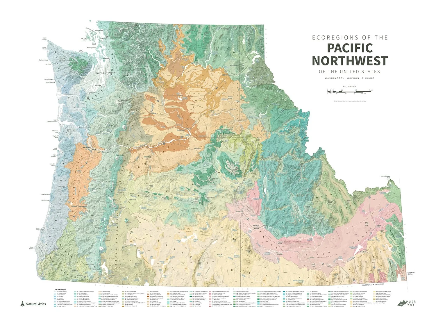
Ecoregions of the Pacific Northwest
There’s something very satisfying about seeing familiar landscapes with different boundaries overlaid on them. Ecoregions provide a handy way to symbolize areas with similar ecosystems and to visualize the diversity of a region in beautiful colors. Natural Atlas already had this wonderful color palette established for all the level III and IV ecoregions, so we took it and draped it over some nice shaded relief and placed a whole lotta labels to identify everything. Squeeze in an exhaustive legend at the bottom and you’ve got yourself a beautiful new view of Oregon, Washington, and Idaho.
Learn more
Mountains
CASCADES, ROCKIES, SIERRA NEVADA
Mountains are without question my favorite landscapes to map. To be more specific, I enjoy peaks that rise well above treeline, particularly if they have perennial snow or glacier-clad flanks. Living in the shadow of the Cascades, this series was born of that love for the high summits of the west and regular views of the Three Sisters west of Bend. I began with the higher Oregon Cascade peaks before expanding north to the icier volcanos that reside across the Columbia in Washington (I must admit, Rainier is my favorite of these maps). Later additions to the series have ventured beyond the Cascades, and I hope to add more 14ers and Sierra Nevada summits in the future. Just a matter of finding the time.
See the full collection
Peakscapes
Iconic mountain skylines
Playing around in Natural Scene Designer, I was quickly inspired by the idea of creating simple views of the mountain ranges that I love. Throw in some peak labels and elevations, and the scene was complete: a mountain identifier beautiful enough to grace a wall and remind the viewer of the grandeur of a given alpine vista. The sunset color gradient is a particular favorite of mine, built to imitate the colors of a day ending in the Great Smoky Mountains but applicable across ranges worldwide.
Peakscapes are now a part of the Raven Maps & Images line of prints. See the full collection here.
Cascade Lakes
FROM SPARKS TO CRATER
Living in Bend, the allure of the Cascade Lakes Highway is inescapable. This series began as an homage to the lakes I frequented when working as a naturalist guide, leading canoeing and kayaking trips on these scenic waters. After making a few, I decided to expand the collection slightly to include other well-known lakes nearby. It was fun to develop this simple style, highlighting the bodies of water themselves with hints at their geographic context and the bathymetry below their surfaces.
See the full collection
Wild Olympics
MOUNTAINS AND RIVERS OF THE OLYMPIC PENINSULA
It was a thrill to be a part of the Wild Olympics campaign, getting the opportunity to make a map highlighting one of the most fascinating landscapes anywhere in the country. The rivers of the Olympic Peninsula drain rugged and remote ridges and peaks, passing through deep gorges and lush rainforests en route to the ocean. In addition to showcasing the drama of this terrain, this map highlights the proposed wild and scenic rivers as well as additional wilderness areas. These designations would further protect the Olympic Peninsula’s spectacular scenery and natural resources, preserving these wonders for generations to come.
Trails
simple views of classic routes
A hike is always my first choice when it comes to outdoor pursuits, and the line of a trail on a map is a beautiful thing. This project began with the idea of the trail line being the main focus of the map, leaving physical features and labels in the background as suggestions of the terrain crossed by the route. Incorporating the elevation profile into the neatline gave each map an extra bit of unique character, tying its shape to the shape of the land it represented. Completing this set would be a thrill, but I wonder if it could ever really be complete. How many trails would be enough?
Tennessee State Parks
PARKS AND NATURAL AREAS OF THE VOLUNTEER STATE
When a friend mentioned the idea of visiting all of the state parks in Tennessee, I immediately thought of putting together a map for him to use as a checklist. Eventually, I decided to throw the natural areas in as well to fill the map and highlight more of Tennessee’s varied geography. The end result was a simple map with forests, shaded relief, and major waterways providing a backdrop to the state park system. This map was built using QGIS, Illustrator, and Photoshop.
Mount Saint Elias
SECOND-HIGHEST PEAK IN CANADA AND THE USA
While our son isn’t specifically named for this peak and the national park its southern slopes lie within, I certainly welcomed the symbolism of him sharing a name with such a lofty peak. I worked on this map during my paternity leave. He was the newest member of our house and deserved a custom map to hang on the wall in his room, so in the (relatively few) periods when he was asleep and I was free, I mapped Mount Saint Elias from our home in Oregon. The landscape offers a beautiful array of forms and features with vast ice fields and glaciers, vegetated lowlands, and ocean tendrils reaching up from icy bay and into the fjords at the mountain’s feet. My favorite areas to map have perennial snow/ice, dramatic relief, and a healthy mix of vegetation classes in the land cover data. This map was built using QGIS, Blender, Illustrator, and Photoshop.